



How to Choose a Marine GPS Chartplotter: 2026 Buyer’s Guide
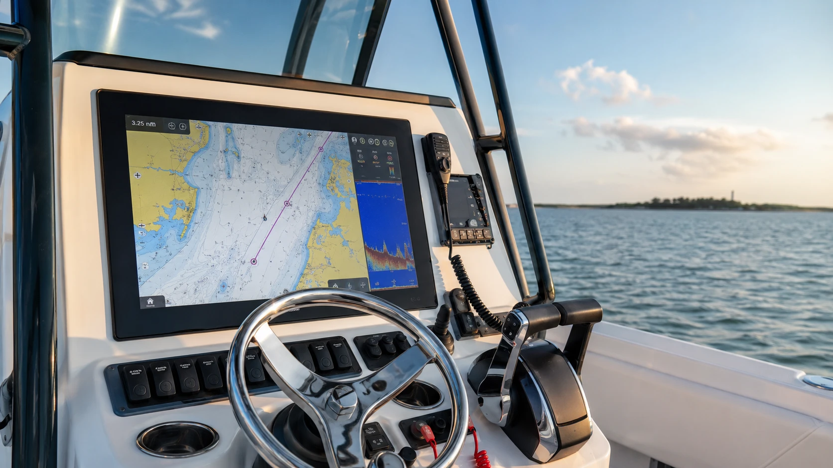
Quick answer: Choose a marine GPS chartplotter by matching six things: your boating area, chart coverage, screen and mounting space, sonar/transducer needs, existing electronics, and future plans for radar, AIS, autopilot or engine data. A larger or more expensive display is not automatically the better system if its charts, ports, transducer or network do not fit your boat.
A chartplotter can make route planning, position awareness and system monitoring easier, but the best choice is a complete, compatible system—not just a display. This guide gives recreational boaters a practical way to narrow the options before ordering.
What is a marine GPS chartplotter?
A chartplotter combines satellite positioning with electronic nautical charts. Depending on the model and connected equipment, it may also display sonar, radar, AIS targets, weather, engine data, cameras, autopilot controls and other vessel information.
Chartplotter
Best when navigation, charts and system expansion are the priority. Sonar may require a compatible sounder and transducer.
Fishfinder
Best when sonar is the main need. Some fishfinders have GPS but may offer fewer navigation or networking features.
GPS/fishfinder combo
A practical all-in-one option when both chart navigation and sonar are needed at one helm.
Choose in this order
Inland lake, river, coastal or offshore use determines the chart coverage and features that matter.
Confirm the cutout, overall dimensions, viewing distance, sun exposure and space behind the dash.
Check the exact region, included chart package, update method and optional premium layers.
Confirm transducer type, connector, frequency, power rating, mounting style and hull suitability.
List radar, AIS, VHF, autopilot, engine, audio, cameras and existing network components.
Budget for mounts, cables, network parts, circuit protection, sealant, chart cards and professional labor where appropriate.
Screen size: fit and readability matter more than boat length
| Display range | Often suits | Check before buying |
|---|---|---|
| 5–7 inches | Kayaks, skiffs and compact helms | Can charts and sonar be read comfortably at your normal viewing distance? |
| 7–9 inches | Small and midsize recreational boats | Is split-screen use practical, and do the dimensions fit the dash? |
| 10–12 inches | Busy single-display helms and offshore fishing setups | Confirm current draw, mounting strength, rear clearance and protective cover space. |
| 16 inches and larger | Large helms, multi-function and multi-display systems | Plan network bandwidth, power, redundancy, sight lines and professional installation. |
These are planning ranges, not rules. Helm geometry, eyesight, viewing distance and the number of simultaneous data panes may matter more than boat length.
Charts: verify coverage before choosing the display
- Coverage: Confirm your exact lakes, rivers, coast or offshore region—not just the country shown on the package.
- Chart source: Check which cartography families the unit supports and whether charts are included.
- Updates: Understand update eligibility, subscriptions, Wi-Fi/app requirements and memory-card needs.
- Fishing layers: If important, compare depth contours, relief shading, satellite imagery and community data.
- Routing: Treat automatic route suggestions as planning aids. Review the route against current charts, conditions, vessel draft and local knowledge.
Sonar and transducer compatibility
The transducer is part of the sonar system, not a universal accessory. Two connectors that look similar may use different pinouts or sonar technologies. Before ordering, verify:
- the chartplotter’s built-in sonar capabilities or required external sounder;
- the manufacturer’s approved transducer list and any required adapter;
- frequency and sonar technology, including traditional, CHIRP, side/down imaging or live sonar;
- transducer power rating and supported impedance;
- transom, in-hull, thru-hull or trolling-motor mounting requirements;
- hull material, deadrise, fairing-block needs and safe drilling location;
- temperature, speed and other sensor data required.
Shop transducers or review transducer accessories.
NMEA 2000, NMEA 0183 and brand ecosystems
NMEA 2000 is a standardized marine data network that can connect certified equipment from different manufacturers. However, a physical connection or shared standard does not guarantee that every feature, proprietary function or software version will work together. Confirm the data messages, gateways, display support and manufacturer documentation for the exact models.
Older equipment may use NMEA 0183, a serial interface with talker/listener wiring. Connecting it to a newer network may require a compatible gateway and careful configuration. A healthy NMEA 2000 backbone also requires correct power, termination and topology.
Browse NMEA cables and sensors.
Radar, AIS and autopilot planning
Radar
Useful for detecting land, weather and targets in reduced visibility, but performance depends on installation, settings and operator skill. Verify display and radar compatibility before purchase.
AIS
A receiver can display broadcasts from equipped vessels; a transceiver can also broadcast your vessel data when properly installed and configured. Not every vessel carries or transmits AIS.
Autopilot
Compatibility depends on the pilot computer, drive unit, sensors, steering system, vessel characteristics and supported control interface—not only the chartplotter brand.
Shop marine radar, AIS systems or autopilots.
Which brand should you choose?
Start with the equipment already on the boat and the features you intend to add. Major marine electronics brands offer capable systems, but the best ecosystem is the one with verified compatibility, suitable charts, accessible service and an interface you can use confidently.
| Decision factor | What to compare |
|---|---|
| Existing equipment | Radar, transducer, autopilot, sensors, network cables and software generation |
| Navigation | Chart availability, updates, route planning and local coverage |
| Fishing | Supported sonar technologies, transducer choices and screen layouts |
| Expansion | Ports, networking, cameras, engine data, radar, AIS and additional displays |
| Ownership | Warranty terms, installation requirements, support and update policy |
Installation and electrical checklist
- Follow the current manufacturer installation manual for every component.
- Use marine-suitable wire, terminals, overcurrent protection and connection methods.
- Verify operating voltage, peak current and voltage drop for the complete system.
- Keep power, networking and transducer routing consistent with manufacturer guidance.
- Seal penetrations using a method compatible with the hull or core material.
- Maintain compass-safe distances and radar mounting clearances.
- Back up settings, update software carefully and test every integration at the dock and underway.
Complex radar, autopilot, thru-hull transducer, high-current or multi-network installations are strong candidates for a qualified marine electronics installer. The National Marine Electronics Association provides recognized installer training and certification programs.
Buyer’s checklist: information to gather before ordering
- Boat make, model, year, length and primary boating area
- Helm photos and exact available dimensions
- Existing display, radar, transducer, autopilot and network model numbers
- Required charts and sonar style
- 12- or 24-volt system and available circuit capacity
- Desired future additions
- DIY or professional installation plan
Frequently asked questions
Can I mix marine electronics brands?
Sometimes. Standardized data such as supported NMEA 2000 messages may pass between certified devices, while radar, sonar, autopilot controls and advanced features are often model- or ecosystem-specific. Verify each connection and function.
Do I need a chartplotter if I use a phone or tablet?
A mobile device can be a useful planning tool or backup, but a fixed marine display is designed for helm visibility, mounting, vessel power and integration with marine sensors. Choose redundancy appropriate for the trip.
Will any transducer work with any chartplotter?
No. Match the exact display or sounder, connector, frequency, power, sonar technology and mounting application using current manufacturer documentation.
Is AIS a replacement for radar or a visual lookout?
No. AIS only shows received broadcasts from appropriately equipped and operating vessels. It complements—but does not replace—radar, visual lookout and prudent navigation.
Should I buy the largest screen I can afford?
Buy the display you can see, mount, power and use safely. A well-planned smaller system may be better than an oversized display that compromises sight lines, fit or budget for charts and sensors.
Build a compatible marine electronics system
Start with your boat, boating area and existing equipment. Verify every display, chart, transducer, radar and network connection before ordering.
Shop GPS chartplotters Ask a compatibility questionMarineWaze editorial note: Product capabilities and compatibility can change by model, software version and region. Confirm current manufacturer documentation before purchase or installation. This guide is educational and is not a substitute for the product manual, current official charts, applicable regulations or professional installation advice.
Recent Posts
-
How to Choose the Right Boat Transducer: 2026 Buyer’s Guide
Quick answer: Choose a boat transducer only after matching the exact chartplotter or sounder, s …Jul 24th 2026 -
How to Choose a Marine GPS Chartplotter: 2026 Buyer’s Guide
Choose the display, charts, sonar and network as one compatible marine electronics system. Quick …Feb 26th 2026